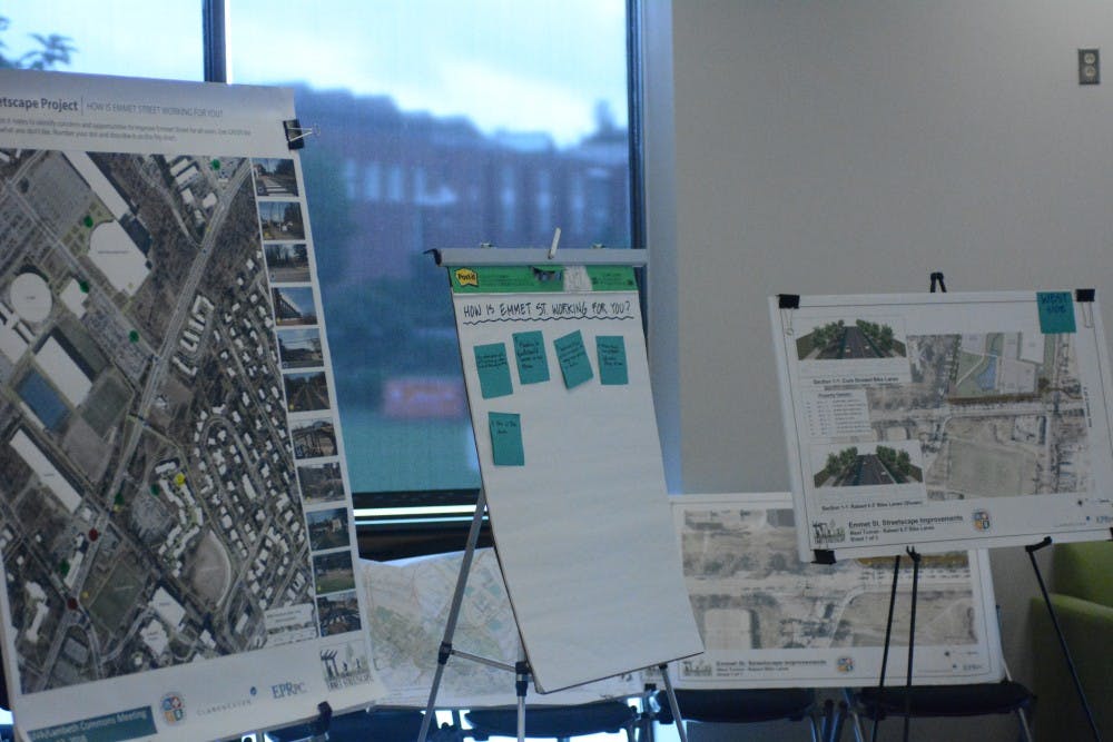
The City of Charlottesville solicited feedback on designs for Emmet Street infrastructure development during a student input session at Lambeth Commons Monday afternoon.
The presentation of preliminary designs is just one step in a six-year, $12 million project funded by the Virginia Department of Transportation’s Smart Scale program. In February, the City commissioned architecture and engineering firm Clark Nexsen to take on the project.
The project aims to add bike lanes, improved bus stops and shared-use pathways to the stretch of Emmet Street between the Ivy Road intersection and Barracks shopping center.
At Monday’s informational open house, students and community members surveyed plans on display and expressed some dissatisfaction with the current function and aesthetics of the street.
“Just inconvenient — I feel like that’s one word to describe Emmet all the way around,” said Alia Chaudhry, a third-year College student and former Lambeth resident.
Second-year College student Leah Taylor said the fast-paced traffic and narrow bike lanes make biking more difficult.
“Anywhere else it’s not too much of a problem to bike on the street, but on Emmet I’d really just rather bike on the sidewalk,” Taylor said. “If they have something that could separate the bike lane even a little bit from the cars, that would be a better option.”
According to a study by the City, nearly 1,000 pedestrians and 145 bikers use Emmet Street every day, largely as a thoroughfare connecting the University to the Lambeth Residence Halls, North Grounds facilities and more.
At the meeting, the City solicited input on the location of the multi-use path and the style of bike lanes. The path will run on both sides of the roadway north of Massie Street, but only one side south of Massie. The City presented separate designs for paths along the east side and the west side, hoping to gauge public preference.
Charlottesville transportation project manager Timothy Motsch said he supports the placement of the path along the west side of the road, citing heavy traffic for athletic events at the John Paul Jones arena.
“We hear [that after] every basketball game ... people [are] walking to get to the parking structure in this direction, [and] they’re walking in the street because there’s only a four foot sidewalk,” Motsch said.
The proposed path along the east side is diverted away from the road, skirting Carr’s Hill Field to pass underneath the railroad tracks.
“It presents some more challenges in terms of safety and comfort level of the user,” said John Stuart, Clark Nexsen transportation department head.
Peter Krebs, community outreach coordinator with the Piedmont Environmental Council, expressed support for the west side pathway.
“People who are novice cyclists, people who are unconfident runners, people on the edge of active transportation, I think are going to be a little bit daunted by the limited sightlines on the east side concept,” Krebs said.
Representatives from the University took a different stance, expressing support of the project generally but hesitant about the multi-use path placement.
“I think that they have taken into account our original study which recommended the shared use path on the east side,” University Landscape Architect Mary Hughes said, referencing an earlier University study highlighting problems with Emmet Street infrastructure. “I think that would still be our University preference. The City feels there are more destinations and fewer encumbrances on the west side, so that’s their preference.”
The City and the University also slightly diverge in their land-use interests along the Emmet Street corridor. The extended width created by bike lanes, sidewalks and a five-foot tree buffer will require the city to acquire some land owned by the University.
“What they’re showing does require a lot of University property,” University Architect Alice Raucher said. “How much that impacts our ability to develop, for something that is going to be both community and University focused, is of concern to us. We’re hoping that wherever this path lands will not impact our ability to develop our property.”
The University is currently working on a separate project to redevelop its property along the Emmet-Ivy corridor.
“It’s a big entrance corridor to the University of Virginia ... so we’re going to have a lot of interest in the aesthetics of the plan so that it really does signal to people that they’ve entered Grounds,” Hughes said.
The Emmet Street project is funded by the Virginia Department of Transportation’s Smart Scale program, which allows localities to apply for subsidized streetscape improvement projects.
The City is continuing to solicit feedback from students and community members on designs for the project via a survey on the project’s website. Once easement issues are resolved and a construction firm is chosen, the project is slated to take 15 to 18 months, with tentative completion set for early 2020.
Read More
What does the University’s contract with dining service Aramark entail?
By Brandon Kile | 16 hours agoThe Cavalier Daily submitted a Freedom of Information Act request to the University for its contract with Aramark to understand the specific terms of the agreement.

Students have federal internship offers rescinded due to hiring freeze
By Nina Broderick | 3 days agoUntil July 15, no presently vacant federal civilian positions may be filled, and no new positions may be created.
Man dies from self-inflicted gunshot wounds at the Rotunda
By Ford McCracken | 3 days agoThe investigation is ongoing, and additional details are not available at this time.

