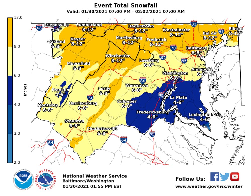
In the lead-up to what appears to be Charlottesville’s first serious winter storm of the season, the National Weather Service has issued a Winter Storm Warning for snow accumulations of four to eight inches.
According to the National Weather Service, a Winter Storm Warning is issued if hazardous winter conditions are ongoing or imminent.
In a tweet, the University of Virginia Office of Emergency Management acknowledged the threat, writing that six to eight inches of snow alongside up to a tenth of an inch of ice is possible.
The snow, which is forecasted to begin late Saturday night or early Sunday morning, will likely be the first significant snowfall for the Charlottesville area in more than a year.
Charlottesville has been flirting with a historic snowfall drought. The last time McCormick Observatory reported more than one inch of snow was Jan. 8, 2020 — 388 days ago. The current record for the number of days in a row without an inch of snow is 388, a streak that lasted from Jan. 28, 2011 to Feb. 19, 2012.
According to the National Weather Service’s probabilistic maps, which are experimental products, the chance of at least two inches of snow in Charlottesville is 100 percent, meaning it is unlikely that the record will be broken.
With temperatures not expected to get above freezing, the snow should easily stick to most surfaces, including roadways and sidewalks.
The Culpeper District of the Virginia Department of Transportation, which includes Charlottesville, has begun pretreating roads across the area. According to VDOT, when the roads are covered with approximately two inches of snow, the plows will begin removing snow from the roadways.
There are significantly more questions about a potential second round of snow, which has the potential to impact Charlottesville and surrounding areas, though it is more likely to strike areas closer to Washington D.C. and Baltimore.
The first round of snowfall from Saturday to Sunday evening is agreed upon by almost every computer model. As the storm shifts to form a coastal low off the coast of the Carolinas, uncertainty grows on how much additional wintry precipitation, if any, will fall in Charlottesville on Monday and Tuesday.
“Our Severe Weather Assessment Team will be monitoring the forecast throughout the weekend and COVID testing will be part of the decision-making process as we look at potential changes to operations,” University Spokesperson Wes Hester said.
Dean of Students Allen Groves addressed the impending weather and its potential impact on University services in a University-wide email Saturday afternoon. Given that many classes will be held fully online this semester — only 27 percent have an in-person component — the University may continue with virtual classes, Groves said, even if in-person instruction is not possible.
Any changes to the University’s operating status will be posted on the @UVA_EM Twitter account and on the Academic Operations Status Board.
Read More
New housing legislation set to alter Charlottesville’s tenant-landlord relationships
By Luca Bailey | 1 hours agoThe new laws are the latest in a series of reforms aimed at curbing Virginia’s record-high eviction rates.

U.Va. Health becomes first health system in Virginia to offer new melanoma treatment
By Vrinda Vashisht | 6 hours agoU.Va. Health interventional radiologist Dr. Daniel Sheeran and U.Va. Health Cardiac Anesthesiologist Dr. Paul Gallo helped bring the treatment to U.Va. Health.

Gregory Perryman reflects on term as Board of Visitors student representative
By Abigail Larkin | YesterdayPerryman expressed his belief that it was particularly important, given the administrative changes, to consistently make students’ concerns known to the Board.