Another winter storm is set to bear down on the Charlottesville region after the previous two storms brought down trees and power lines, leaving many residents in the dark for days.
The system that will begin impacting Charlottesville on Saturday is part of a large storm system that is predicted to bring snowfall potentially as far south as Atlanta all the way up into the Canadian Maritimes.
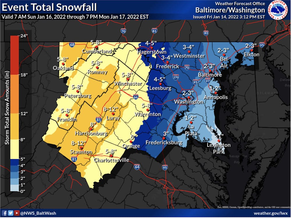
A Winter Storm Watch has been issued for Charlottesville from Sunday afternoon to Monday morning, with accumulations of 5 to 8 inches of snow expected and up to 10 inches of snow possible, especially at higher elevations.
Much like the Jan. 3 storm that caused many in the area to lose power, the snow is expected to fall at one to three inches per hour, a rapid rate that may make travel difficult if not impossible.
Winds are also expected to gust at up to 40 miles per hour, potentially downing stressed power lines and tree limbs. Following the Jan. 3 storm, more than 64 percent of Albemarle County residents lost power, as well as more than 12,000 residents in Charlottesville. For some, it took days for power to return.
To make the potential power outage situation even worse, ice accumulations are also expected, with one to two-tenths of ice forecast in the Charlottesville area. Ice accretion on power lines can be serious, with a half-inch of ice accumulation on power lines adding 500 pounds of extra weight. At this time, that much ice is not forecast.
Further north, Washington D.C. is also under a Winter Storm Watch. The nation’s capital is expected to see one to three inches of snow, up to a tenth of an inch of ice and wind gusts of up to 45 miles per hour.
Currently, the National Weather Service forecasts a high-end amount of snowfall — which it describes as having a 1-in-10 chance of occurring — as 11.9 inches in Charlottesville and 5.3 inches in Washington D.C.
Temperatures are expected to be frigid Sunday morning, with temperatures below 20 degrees possible. However, the temperature will rise throughout the day Sunday, especially in the upper levels of the atmosphere. When temperatures warm aloft but stay freezing closer to the ground, sleet and freezing rain are possible, potentially limiting the accumulation of snow, but still causing a slippery mess.
Exactly how warm it gets will dictate the amount of snow and ice the Charlottesville area will experience. It is possible that temperatures rise above freezing in the Charlottesville area during the storm, allowing for light rain and the accumulated ice and snow to melt slightly before refreezing later in the storm.
“However, at this time the most likely scenario is a heavy burst of snow on the front end for most as the storm moves into the region Sunday afternoon, followed by a mix to ice during the evening and plain rain possibly (sic) for areas near and east of I-95,” the National Weather Service wrote in its most recent forecast discussion.
Additional light snow is possible Monday, with more wintry weather expected in recent weeks.
Read More
Health System Board hears presentations on Ehlers-Danlos center, at-home patient care
By Luca Bailey | 7 hours agoHSB is a Board committee composed of seven Board members that oversee the operations of the University’s Medical Center and provide strategic oversight for the School of Medicine, the School of Nursing and U.Va. Community Health.

U.Va. Wise Committee discusses Fall 2026 enrollment, Year in Wise program growth
By Melody Yuan | 7 hours agoThe Committee on the College at Wise oversees the College at Wise and serves as the Board’s dedicated committee for the University’s Wise, Va. campus.

Buildings and Grounds approves entrepreneurship building design, FY 27 capital plan
By Grace Little | 7 hours agoThe Buildings and Grounds Committee oversees the University’s land use planning and the care, maintenance and security of buildings across Grounds.